HomeExercises |
 |
ARCH4050 / ARCH6050 / MUDD6050 Tutorial 9 - Land Use Mix Objectives:
Background:In this tutorial, you will learn how to count different types of land use categories at the census tracts level and use this information to measure land use diversity. You will then apply the same method to understand diversity in housing choices and other related measures. SetupCreate a new directory on your desktop, name it lab9. Click here to download a zip file, which contains a dataset for this tutorial. Save this in your lab9 directory, then when the download is complete, extract the file there; you will now have a set of shapefiles and two Excel files in that directory. Open ArcMap. Click File > Add Data, select all four shapefiles, and add them to the Table of Contents in your ArcMap file.
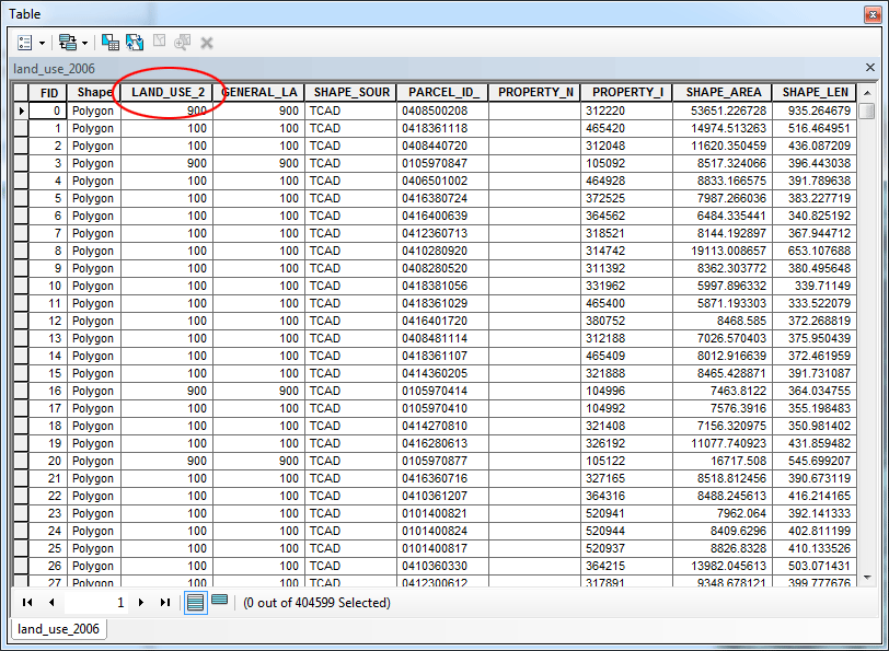
Turn off all the layers except leaving the layer land_use_2006 on. View the new layer and its attribute table to verify that everything came out OK. You want to make sure that the attribute table contains the LAND_USE_2 field and that all parcels display on the map.
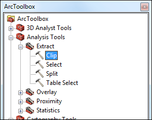
The land_use_2006 layer covers some areas outside Travis County. You want to select only parcels that are within the county boundary. You will then use the census tracts layer to clip the land use layer. To clip one layer based on another, the user must use Clip found in the Extract portion of Analysis Tools in ArcToolbox.
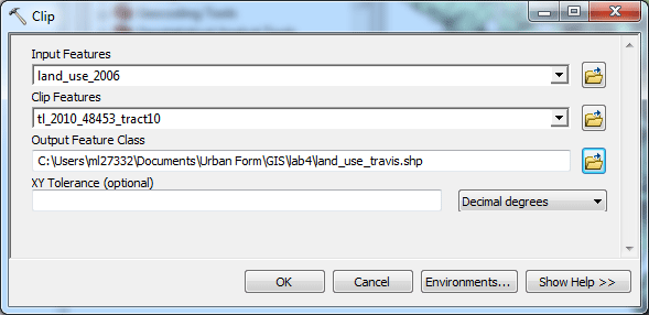
In the Clip dialogue box, you choose land_use_2006 layer as the Input Features, and choose the census tracts layer as the Clip Features, and name your output layer (output feature class) land_use_travis, save it in your directory, then you click OK to finish clipping. You will see that the output layer will be added into your map.
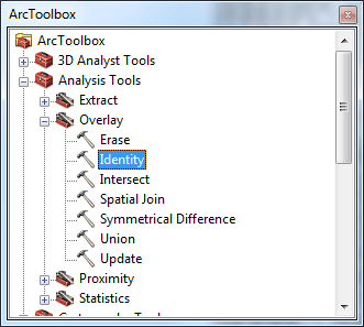
Remove the original land_use_2006 layer. Count parcels within census tracts based on land usesTo tally the parcels within each census tract it is necessary to assigns the census tract ID number to each parcel. In order for this to be done, each parcel must be coded for the census tract in which it lies. To encode the parcels with the census tract ID, use the tool Analysis Tools > Overlay > Identity
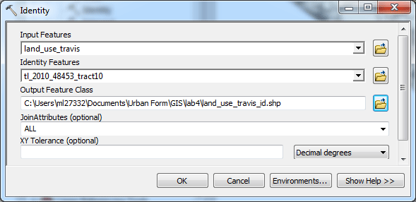
In the dialog, set the input features to land_use_travis and the overlay features to the buffers tl_2010_48453_tract10. Name the output feature class land_use_travis _id.shp.
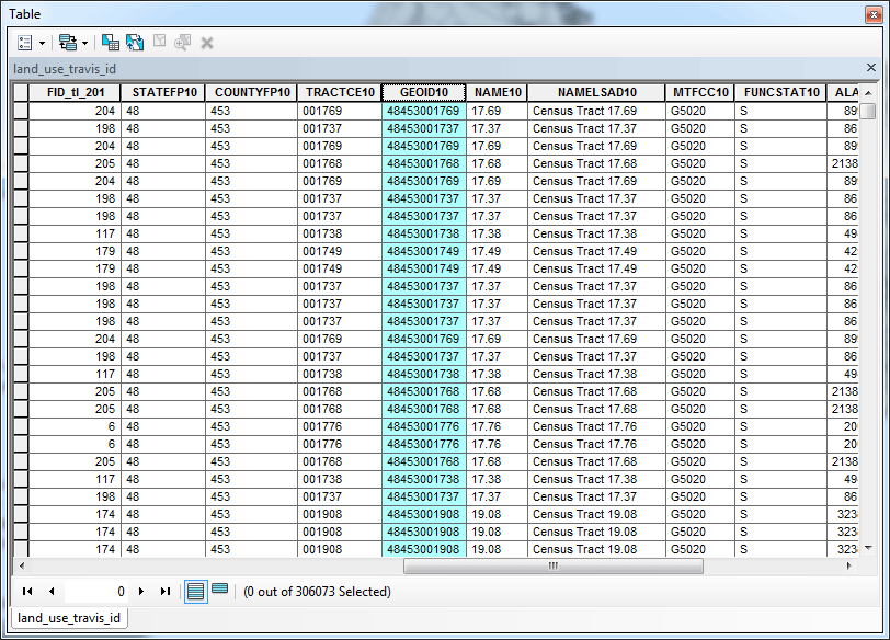
The polygons in a new layer will appear the same in the map display, but the attribute table now contains values for the field GEOID10, which is the unique identifier for census tracts. Open the attribute table for this new layer.
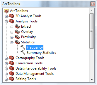
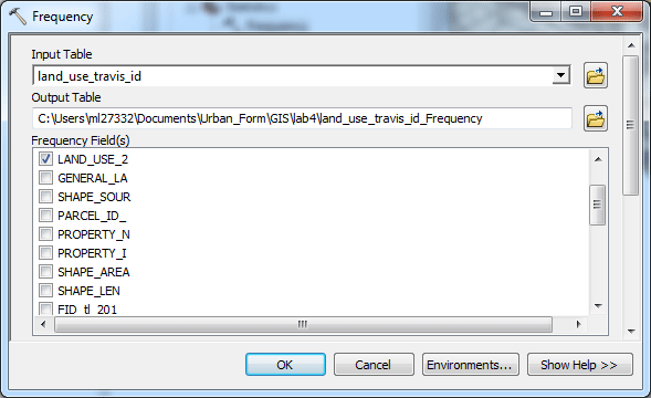
The next step for tallying the land uses within each census tract is to run a frequency function. in the ArcToolbox, Use the tool Analysis Tools > Statistics > Frequency.
In the dialog, set the input table to land_use_travis _id. Name the output table land_use_travis _id _Frequency. Use the Frequency Field(s): LAND_USE_2 and GEOID10. This will tally up all the occurrences of combinations of land uses and census tract IDs.
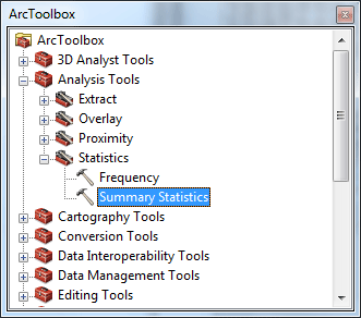
Examine land uses within census tractsTo determine how many different types of land uses within any given census tract, it is necessary to run a data summary. Use the tool Analysis Tools > Statistics > Summary Statistics.
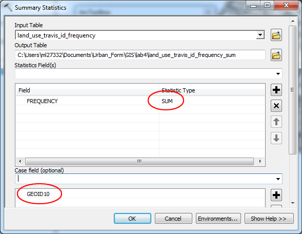
Set the input table as land_use_travis _id _Frequency. Name the output table land_use_travis _id _Frequency_sum. Click the dropdown menu for the Statistics Field then select FREQUENCY, and click the field Statistic Type then select SUM from the dropdown menu. Select GEOID10 as the Case field.
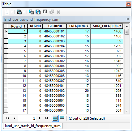
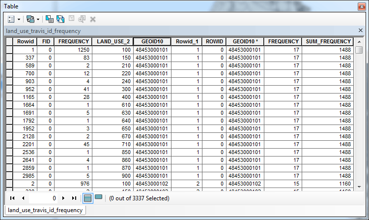
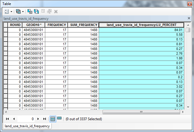
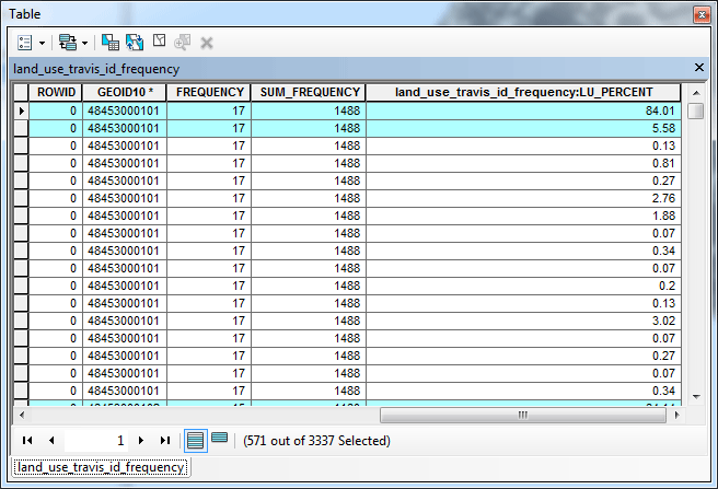
This new table shows the frequency of different types of land uses as well as the sum of parcels with all land uses for each census tract. Using the table below as an example, tract 48453000101 has 1488 parcels, and 17 different types of land uses. By contrast, tract 48453000203 has 39 parcels, and 8 different types of land uses.
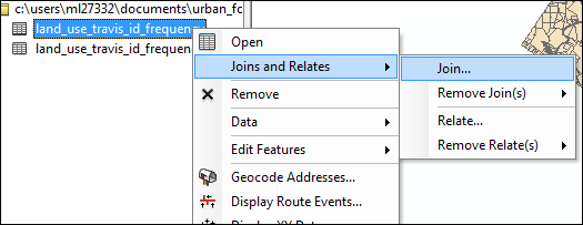
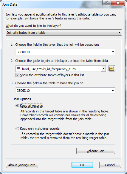
Calculate Land Use Diversity Index Use the total number of different types of land uses may not be a good indicator for measuring land use diversity, because for a given census tract, certain types of land uses may be so dominant and make this tract actually very uniform in terms of land use diversity, even though this particular tract may still contain quite a few other types of land uses in relatively smaller quantities. You need to calculate the percentage of different land use types to the total parcel counts for each of the census tracts. To do that, you need to join the second table land_use_travis _id _Frequency_sum back to the first summary table land_use_travis _id _Frequency. Perform a join of the summary table onto the land_use_travis _id _Frequency table (right-click land_use_travis _id _Frequency in the Table of Contents, select Joins and Relates > Joins).
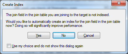
Click No, when asked to create an index for join field.
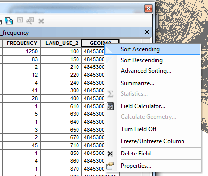
Open the land_use_travis _id _Frequency table, now you have the total number of parcels for each of the census tracts. To calculate the percentage of different land uses, you need to add a new field. Right-click GEOID10 and select Sort Ascending to see census tract IDs grouped together.
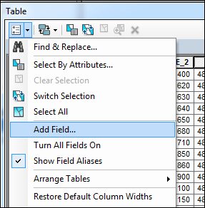
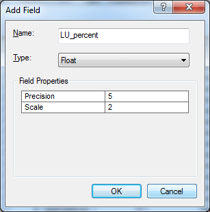
To calculate the percentage of land uses, select Table Options > Add Field (click the icon on the up-left corner) and add a field to the land_use_travis _id _Frequency table, name the new field LU_percent, as a Float field type.
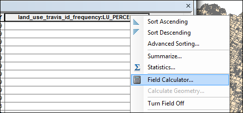
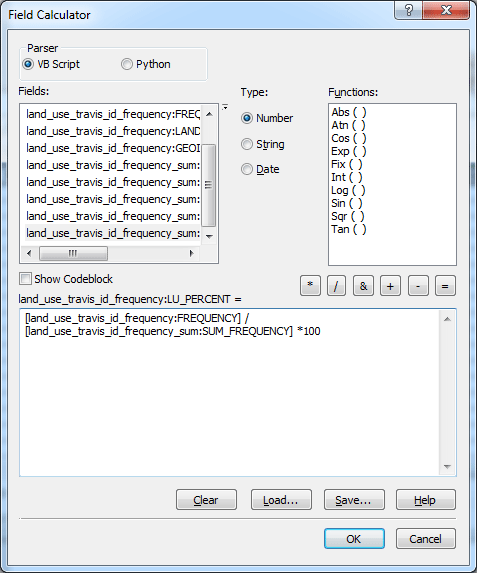
Find the field (scroll back to the right in the list of fields), right-click on the land_use_travis _id _Frequency:LU_percentcolumn heading and select Field Calculator.
to determine the percentage of land uses within any given census tract: set the query as: [land_use_travis_id_frequency:FREQUENCY] / [land_use_travis_id_frequency_sum:SUM_FREQUENCY] *100
The results are added in the new field.
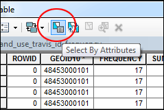
As you can see, many census tracts have some land use categories with very low percentages, while other land uses are so dominant. For this exercise, you will only count those land use categories that receive at least 5% of share within a census tract for measuring land use diversity. Open the land_use_travis _id _Frequency table again if you already closed it. Click Select by Attribute icon,
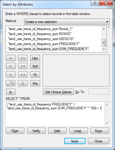
Set the selection query as the following: ( "land_use_travis_id_frequency:FREQUENCY" / "land_use_travis_id_frequency_sum:SUM_FREQUENCY" * 100) > 5
Click Apply, then you should see that only the records that fit the criterion are highlighted.
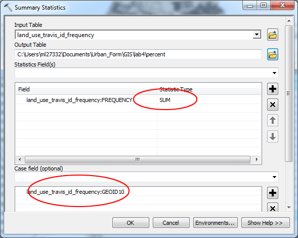
With the selection is still active, close the table, run a data summary again. Use the tool Analysis Tools > Statistics > Summary Statistics.
Set the input table as land_use_travis _id _Frequency. Name the output table percent. Click the dropdown menu for the Statistics Field then select land_use_travis _id _Frequency:FREQUENCY, and click the field Statistic Type then select SUM from the dropdown menu. Select land_use_travis _id _Frequency:GEOID10 as the Case field. Click OK.
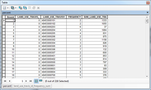
This new table shows the frequency of only the selected land uses as well as the sum of those parcels for each census tract. Using the table below as an example, tract 48453000101 has 1333 parcels, and 2 types of land uses that count more than 5% of the total land uses. By contrast, tract 48453000203 has 37 parcels, and 6 different types of land uses that count more than 5%. So, we can say that tract 48453000203 is more diverse than tract 48453000101 is in terms of land use diversity.
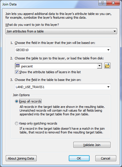
Close the percent table, in the table of content, turn the land_use_2006 layer off, turn on the census tract layer. Perform a join of the summary table onto the tl_2010_48453_tract10 table (right-click tl_2010_48453_tract10 in the Table of Contents, select Joins and Relates > Joins). Set the settings as the follow:
Click No, when asked to create an index for join field.
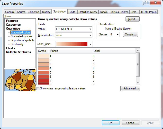
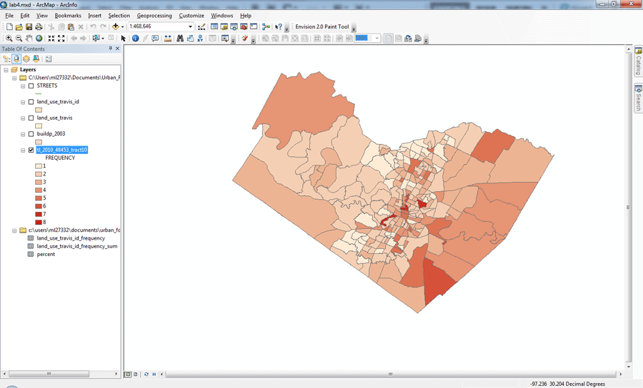
Be sure to use GEOID10 as the IDs for the layer and LAND_USE_TRAVIS1 for the precent Table. When done, open the attribute table again, and you should find a field that contains frequency for all the census tracts. Now you can play with symbology to change the way ArcGIS displays this layer. Right-click the layer again, and choose Properties, then Symbology, In the dialog, set the settings as shown below.
1. Shows: Quantities > Graduated colors then apply these new settings to your layer as shown below
You can use the same methodology to examine the land use diversity at a different geographic scale, such as a neighborhood; or look at diversity on other factors, such as housing types, demographic data.
prepared by Ming-Chun Lee, 03/15/2014
|